GPRS used to stand for “Gotta Problem Ruining Stuff.” It was the common refrain of contractors who dug blindly into uncharted soils or drilled into concrete slabs, only to intersect and damage undetected utility lines or pipes or steel components. Sparks would fly, or worse. Service often was interrupted. The excavation or drilling project itself always was thrown off schedule. It was bad news all the way around.
The good news is that another GPRS — the initials this time standing for “Ground Penetrating Radar Systems” — has come along to give direction to engineers, project supervisors and equipment operators.
The Toledo, Ohio, firm by that name is showing contractors the way around hidden obstacles so that new and old infrastructure can co-exist beneath the surface.
The company is the brainchild of entrepreneur Matt Aston, who began peddling his subsurface detection service from job site to job site in and around Toledo in 2001. One by one, he gained construction industry converts to the concept of preventing underground collisions by probing soil or scanning concrete before tearing into it.
Twenty-one years later, Aston’s company is national in scope with field staff in all 50 states and every major city and seems to be hitting its stride. In an interview in 2021, Aston said the goal at GPRS was to continue to create awareness of the technology and to double the size of the company in the following three or four years.
GPRS didn’t invent ground penetrating radar — the technology dates from 1910 — but it certainly has helped popularize its use. Jamie Althauser knows all about the rapid growth of GPRS. He has been helping foster and manage the company’s growth for 15 of its 21 years in existence. Working from the Toledo headquarters, his title is field support director.
Althauser began out in the field, which is to say he operated a GPR unit to probe open areas and scanned concrete. Now he works from an office and principally oversees safety and skills training of new employees. That is a task large enough to keep him busy, because the company now employs more than 700 people, roughly 400 of them operating in the field.
How all these people work within the framework of the company goes hand in hand with how the framework was constructed in the first place. When Aston realized how little awareness of and/or access to radar and scanning services existed in cities that he visited, he concluded that sending out and establishing field workers in cities across the country was the way to build the company.
This scattering of field personnel was key to the company’s success, Althauser says. “It makes us different from other locating companies. Where they built up a big presence in one city and expanded outward, we started by expanding outward across the country and hiring people we could trust to build the business where they were.”
The founder heeded his entrepreneurial instincts in deciding to give the field personnel a level of autonomy that sparked in them a sense of ownership. They are not independent contractors, as such, but are given the leeway to make decisions without first calling the home office.
“All of the field people are called project managers, rather than techs,” says Althauser. “Giving them that title is part of our company culture. Each is responsible for good customer service. They are aware of pricing and can change the prices as needed to win a job. We give them a lot of ownership over the projects they’re doing. They are not just techs with a goal of getting a job done. They are managers building relationships with clients.”
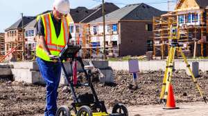
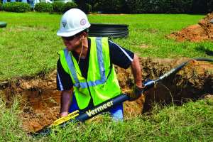
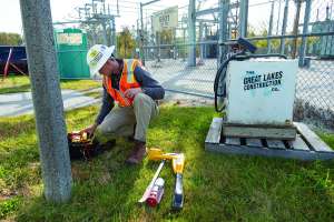
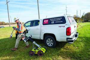
Most of the time project managers work on their own in one city or another, though sometimes they are dispatched to jobs by Toledo managers. On large construction projects, the project managers may team up with other managers. Typically, however, their days are spent driving alone to a site in a Chevrolet Colorado service truck to electronically probe the ground or peer inside vertical or horizontal slabs of concrete.
“The project managers are incentivized to grow the business, take care of clients and work as efficiently as possible,” the field support director says of the project managers, the incentives including commissions. “They are building their own little part of GPRS. That’s how the company has grown so fast.”
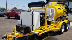
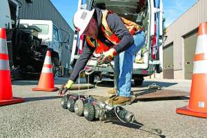
About 80% of GPRS field work is locating utilities in the ground or inside concrete so that a contractor doesn’t damage them. However, the company keeps adding corollary services. Two years ago, for instance, it introduced video pipe inspections, which has grown into a coast-to-coast slice of the company pie.
Other recent additions to the GPRS lineup include leak detection, drone imaging and, most recently, 3D laser scanning. “We wanted to provide the other services to add value for our clients,” Althauser says. “All of the services are growing rapidly, including the ones added after the fact.”
While drilling or digging contractors are the typical client, actual job sites are atypical. They could be anywhere — from university campuses to McDonald’s franchise construction sites, from oil refineries to athletic facilities.
And the contractors making the calls are of all sizes, from small mom-and-pop outfits on up to prime contractors on major developments. The broad range of clientele is possible because the services are affordable, especially when compared to the costs associated with striking an active utility line or a hidden underground tank. Because locating is a preventive service, when a bore or dig is completed without incident, the cost always is deemed to be covered.
Though the bulk of the GPRS business is locating utilities and other subsurface manmade structures, clients frequently ask for more — the video inspection of a located pipe, for instance. Regardless, what always follows a scan or GPR survey is a detailed report and a map, which is produced by the project manager before leaving a site.
“Not every customer wants a map,” Althauser says “In the last few years we’ve opted to produce a PDF reference map of everything we locate whether the client asks for it or not. If they want a CAD drawing, that’s extra and is sent to the client within three-to-five days.”
What the company emphatically doesn’t do is engineering work. Though some employees have engineering degrees, no engineering services per se are offered.
“If we offered that, we would have to be licensed and meet state and federal standards,” Althauser says. “By not offering engineering services, we also are not in competition with engineering firms and can be hired by them.”
The company nonetheless holds its project managers to a professional standard. Each is “SIM-certified.” The acronym stands for Subsurface Investigation Methodology and is the company’s way of differentiating itself from other locating companies.
In essence, each project manager is certified to have completed eight weeks of mentoring in the field and 80 hours of classroom training at the company’s training grounds in Toledo. They also are schooled on the utilization of the company’s state-of-the art electronic equipment and instructed on step-by-step procedures required to find hidden objects.
The fruit of all this training? The company claims a 99.8% success rate in locating unseen objects in tens of thousands of projects across the country. “That success rate has improved even as we’ve rapidly grown,” says Althauser, which is a fairly remarkable statistical claim.
He adds: “In the locating industry, there are no professional standards that a company has to meet to be credible. SIM is our answer to that. We created our own standard, a process that every project manager goes through. Most contractors wouldn’t even know what SIM is, but we know, and our reputation is proof of it.”
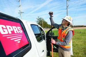
As careful as GPRS is in hiring qualified people, it is just as picky about the equipment it employs. For the first two decades of its existence, the company relied on GSSI units to send electromagnetic impulses into the ground in search of an identifying bounce-back. The company also uses a Swedish product, ImpulseRadar PinPointR, for utility locating and a Screening Eagle Proceq 8800 for concrete scanning.
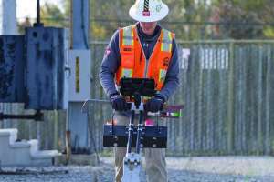
About 20 project managers doing laser scanning have Leica RTC laser scanners and numerous other electronic field tools are available. As needed, the personnel have access to Matterport 360-degree cameras for map-making and modeling and other specialized cameras. CAD maps are created by a team of 20 computer specialists using either AutoCad or MicroStation units and BIM modeling primarily is accomplished with Revit software. Drone work is pretty minimal at GPRS and the drone fleet practically nonexistent. When there are calls for photogrammetry, LiDAR, orthomosaic images and other drone survey products, the work is subbed out.
The newest electronic tool in the GPRS toolbox is what it calls SiteMap. It aggregates all mapping data from aboveground and belowground facility surveys and then digitally stores it in a common area where it can be accessed by a client for complete 3D viewing and facility management.
“It is a really exciting part of our company and completely unique,” Althauser says of the program, which is built on a proprietary software platform. “You will have access to every mapping project you ever hired, all on one platform, and you can share it with other contractors. No other locating company offers this.”
In short, GPRS isn’t just another locating company. In fact, on its website it refers to its combination of locating, scanning, imaging, mapping, and modeling as “complete facility visualization.” That’s GPRS — Got Plentiful Radar Solutions.