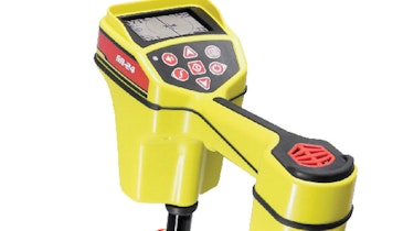
The 3D-GeoSense system from RapidView IBAK North America uses a sensor in the camera to provide users with a 3-D map of the lateral. The XYZ coordinates can be determined when the camera is moving both forward and backward, immediately providing the operator a real-life site plan with the width, length and elevation data of the lateral being inspected. It can be used in push- or lateral-launch applications. Additional third-party software is required. 800/656-4225; www.rapidview.com
Mapping Tools - RapidView IBAK North America 3D-GeoSense
Related Stories


Discussion
Comments on this site are submitted by users and are not endorsed by nor do they reflect the views or opinions of COLE Publishing, Inc. Comments are moderated before being posted.